
Featured Apps
MediaHub
Top News
Stocktracker
Startup Remix
Roblox Robux Calculator
Free Apps (TOP)
Free Apps (NEW)
Paid Apps (TOP)
Paid Apps (NEW)
Top Grossing Apps
Jobsearch Apps
News Apps
Business Apps
Finance Apps
HTML Open Tag Checker
Marketing URL Builder
Percentage Calculator
Inflation Calculator
Loan Interest Calculator
Kids Apps
Dating Apps
Senior Apps
Tradesman Apps
Board Game Apps
Faith Apps
Meditation Apps
AI Apps
EV Apps
Feature Your App
Casting ATL App
The Shop Channel App



FingerGIS App
Price: $ 2.99 USD - $2.99
Genre: Productivity
Developer: Gianluca Natalini Developer: Gianluca Natalini
Seller: Gianluca Natalini Seller: Gianluca Natalini
Rated: 4 out of 5 stars.
Based on 1 reviews.
Shop Collectibles and Memorabilia.
Price: $ 2.99 USD - $2.99
Genre: Productivity
Developer: Gianluca Natalini Developer: Gianluca Natalini
Seller: Gianluca Natalini Seller: Gianluca Natalini
Rated: 4 out of 5 stars.
Based on 1 reviews.
Shop Collectibles and Memorabilia.
Apple AppStore - Google Play
FingerGIS App V. 1.6
by Gianluca Natalini
"FingerGIS" is the first GIS application (Geographical Information System) for iPad, iPhone, iTouch. With "FingerGIS" You can draw (georeferencing): - 2D shapes such as sites, lands, roads or paths ex - More Info...

New Music Discovery with PlaylistDuel.com
AMAZON EBAY WALMART
BESTBUY ETSY
Huge Collectibles - Preorders Bestseller Gifts Shop Disney Collectibles
Top Gifts and Preorders Entertainment Earth SideShow Collectibles
❯ Top Gifts and Preorders.
❯ The FingerGIS App Review from the BigTopApps Team.
🌟 What makes FingerGIS so special? 🌟
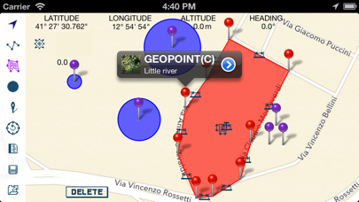
"FingerGIS" is the first GIS application (Geographical Information System) for iPad, iPhone, iTouch. With "FingerGIS" You can draw (georeferencing): - 2D shapes such as sites, lands, roads or paths explorable by car, plane or on foot (in the city, in the countryside, on a hill, in the mountains, at sea, etc...) - 3D shapes such as multiple surfaces...
Whether you're a seasoned pro or a newbie in the digital world, FingerGIS app is designed to make your life easier, more fun, and more productive. Here are just a few highlights:
share
🚀 Price: 2.99 USD
📈 Rating: 4 out of 5 stars. Based on 1 total reviews.
🎨 Content Rating: 4+
💡 New Features:
* Minor bugs fixed
But that's not all! The Gianluca Natalini team is continuously improving and expanding FingerGIS to bring you even more exciting features at the palm of your hand, being last updated at 2026-06-09, the Gianluca Natalini team works hard to stay ahead of the curve and bring you an exceptionally robust, secure, and up-to-date app.
Download and experience FingerGIS now and unlock a new journey in your mobile world – Your mobile device will thank you.! 📱💫
Also don't miss out on future mobile app features. Join the millions who have already discovered the magic of FingerGIS and download BigTopApps Discovery App today, and never miss a new app announcement and feature release again! We are also on the web at BigTopApps.com.
Apple AppStore - Google Play
Shop Collectibles and Memorabilia.
BestBuy - WalMart - Entertainment Earth
FingerGIS App Details
Available Since: 2013-06-27
Developer: Gianluca Natalini
Seller: Gianluca Natalini
Price: 2.99 USD
Current version: 1.6
Last Updated: 2026-06-09
Ratings: 4 out of 5 stars.
Based on 1 reviews. (Rate/Review)
Genre: Productivity
Filesize: 6.60MB
IOS Bundle ID: com.GianlucaNataliniNGCYBIT.FingerGIS
Age Rating: 4+
Languages: EN
Videos: FingerGIS App Videos
Developer: Gianluca Natalini
Seller: Gianluca Natalini
Price: 2.99 USD
Current version: 1.6
Last Updated: 2026-06-09
Ratings: 4 out of 5 stars.
Based on 1 reviews. (Rate/Review)
Genre: Productivity
Filesize: 6.60MB
IOS Bundle ID: com.GianlucaNataliniNGCYBIT.FingerGIS
Age Rating: 4+
Languages: EN
Videos: FingerGIS App Videos
Apple AppStore - Google Play
FingerGIS Updates and Release Notes
* Minor bugs fixed
Please note BigTopApps is not responsible for the content provided by the publicly accessible App Store API.
❯ FingerGIS App Description
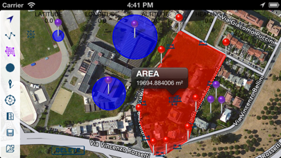
"FingerGIS" is the first GIS application (Geographical Information System) for iPad, iPhone, iTouch.
With "FingerGIS" You can draw (georeferencing):
- 2D shapes such as sites, lands, roads or paths explorable by car, plane or on foot (in the city, in the countryside, on a hill, in the mountains, at sea, etc...)
- 3D shapes such as multiple surfaces in space, air routes, etc...
The generic 2D and 3D shapes can be drawn over the maps (2D and 3D) of the globe, visualized by "FingerGIS" on the screen (Google Maps or Apple Maps), like when You draw using a CAD application.
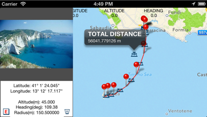
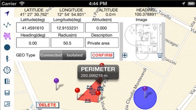
You can query the maps and the geographical points (manually inserted or automatically recorded) in order to obtain lengths, distances between geographic points, measure of areas and perimeters, total length of a path (polyline), etc...
"FingerGIS" provides several automatic recording mode and/or manual input windows to insert the geographical points of interest; You will be able to:
- save the current positions as a new geopoint, during the exploration of a site (using the GPS to get your current location and pressing the "save current location" button to save your current position as a new geopoint)
- enter manually new geographical points using the manual input window (with latitude, longitude, altitude, heading (it uses the device's internal compass), radius, description: these geopoint's data (such as latitude, longitude, altitude, heading, etc…) can be entered automatically by touching with a finger the desired position in the displayed maps (by touching the screen of the device) or manually typing the numerical values / text using the keyboard of the device)
- save images together with geographic points (You can insert images taken with the camera in real time or stored in the photo album of the device and join the images with the geopoints)
- save an infinite number of isolated geographical points and / or circular areas of known radius, etc...
- automatically record sites, activating the "automatic recording" function and walking on the perimeter of the site to be recorded
- draw each type of 2D and 3D objects over the maps of the globe, using multiple layers, as You would normally do with common CAD / GIS / SIT for personal computers.
All geographic points inserted over the maps, with their descriptions, measurements and images can be saved in the archive of documents of "FingerGIS" and may be shared with other applications installed on Your device or with cloud systems such as Dropbox.
"FingerGIS" is able to export the saved geographical points using:
- .csv file format (native "FingerGIS" file format)
- in the native file format of "FingerCAD" (You can draw your CAD projects over geographic maps or over the geo-referenced sites recorded by "FingerGIS")
- in the native file format of "pathRecorder" (navigation system with automated indications to reach destinations, following paths recorded or drawn)
- as an email attachment (.zip compressed file, containing all the recorded geopoints, the informations, data, images, etc...)
With "FingerGIS" You will have a complete GIS application in your mobile device.
Sharing documents (IN/OUT) with:
- DROPBOX (remote storage systems, cloud)
- Open In
- iTunes File Sharing
- email attachment
- FingerCAD (HD , WS , PRO) (using "Open In" - 3D data export/sharing)
- pathRecorder - come back (using "Open In")
Using FingerCAD together with FingerGIS:
You can export the recorded sites using a .DXF file format (compatible with the CAD applications for MAC or PC) or a .OBJ file format (compatible with the 3D modeling applications for MAC or PC) or .PDF file format.
Documents archive:
- an infinite number of documents can be saved in the FingerGIS documents archive
Display:
- Retina display supported
App type:
- UNIVERSAL APP (You pay the app only once and it runs on all the devices)
With "FingerGIS" You can draw (georeferencing):
- 2D shapes such as sites, lands, roads or paths explorable by car, plane or on foot (in the city, in the countryside, on a hill, in the mountains, at sea, etc...)
- 3D shapes such as multiple surfaces in space, air routes, etc...
The generic 2D and 3D shapes can be drawn over the maps (2D and 3D) of the globe, visualized by "FingerGIS" on the screen (Google Maps or Apple Maps), like when You draw using a CAD application.
You can query the maps and the geographical points (manually inserted or automatically recorded) in order to obtain lengths, distances between geographic points, measure of areas and perimeters, total length of a path (polyline), etc...
"FingerGIS" provides several automatic recording mode and/or manual input windows to insert the geographical points of interest; You will be able to:
- save the current positions as a new geopoint, during the exploration of a site (using the GPS to get your current location and pressing the "save current location" button to save your current position as a new geopoint)
- enter manually new geographical points using the manual input window (with latitude, longitude, altitude, heading (it uses the device's internal compass), radius, description: these geopoint's data (such as latitude, longitude, altitude, heading, etc…) can be entered automatically by touching with a finger the desired position in the displayed maps (by touching the screen of the device) or manually typing the numerical values / text using the keyboard of the device)
- save images together with geographic points (You can insert images taken with the camera in real time or stored in the photo album of the device and join the images with the geopoints)
- save an infinite number of isolated geographical points and / or circular areas of known radius, etc...
- automatically record sites, activating the "automatic recording" function and walking on the perimeter of the site to be recorded
- draw each type of 2D and 3D objects over the maps of the globe, using multiple layers, as You would normally do with common CAD / GIS / SIT for personal computers.
All geographic points inserted over the maps, with their descriptions, measurements and images can be saved in the archive of documents of "FingerGIS" and may be shared with other applications installed on Your device or with cloud systems such as Dropbox.
"FingerGIS" is able to export the saved geographical points using:
- .csv file format (native "FingerGIS" file format)
- in the native file format of "FingerCAD" (You can draw your CAD projects over geographic maps or over the geo-referenced sites recorded by "FingerGIS")
- in the native file format of "pathRecorder" (navigation system with automated indications to reach destinations, following paths recorded or drawn)
- as an email attachment (.zip compressed file, containing all the recorded geopoints, the informations, data, images, etc...)
With "FingerGIS" You will have a complete GIS application in your mobile device.
Sharing documents (IN/OUT) with:
- DROPBOX (remote storage systems, cloud)
- Open In
- iTunes File Sharing
- email attachment
- FingerCAD (HD , WS , PRO) (using "Open In" - 3D data export/sharing)
- pathRecorder - come back (using "Open In")
Using FingerCAD together with FingerGIS:
You can export the recorded sites using a .DXF file format (compatible with the CAD applications for MAC or PC) or a .OBJ file format (compatible with the 3D modeling applications for MAC or PC) or .PDF file format.
Documents archive:
- an infinite number of documents can be saved in the FingerGIS documents archive
Display:
- Retina display supported
App type:
- UNIVERSAL APP (You pay the app only once and it runs on all the devices)
Apple AppStore - Google Play
Discussions, Ratings, and Reviews for FingerGIS App
Leave feedback and review FingerGIS
Featured Apps
MediaHub
Top News
Stocktracker
Startup Remix
Roblox Robux Calculator
Free Apps (TOP)
Free Apps (NEW)
Paid Apps (TOP)
Paid Apps (NEW)
Top Grossing Apps
Jobsearch Apps
News Apps
Business Apps
Finance Apps
HTML Open Tag Checker
Marketing URL Builder
Percentage Calculator
Inflation Calculator
Loan Interest Calculator
Kids Apps
Dating Apps
Senior Apps
Tradesman Apps
Board Game Apps
Faith Apps
Meditation Apps
AI Apps
EV Apps
Feature Your App
Casting ATL App
The Shop Channel App
Featured: Mini Game Studio on Android - FREE GAMES
Top Free Apps

TikTok Pro - Events - TikTok Ltd.
1
TikTok Pro - Events is a global discovery platform for videos where you can discover cool, funny, and educational short videos, as well as share important moments with your friends.
Enga...

Muse from Meta - Meta Platforms, Inc.
2
Muse is your personal AI agent that gets things done, always working on what matters to you. It manages email, books dinners, tracks budgets, and finds deals, with your approval.
PERSONA...

Vinted: Pre-loved marketplace - Vinted Limited
3
The idea is simple: you sell your pre-loved stuff to other members who’ll love it again. They get the thrill of unboxing a great find, you get more space at home. It's look-good, do-good,...

ChatGPT - OpenAI OpCo, LLC
4
Introducing ChatGPT for iOS: OpenAI’s latest advancements at your fingertips.
This official app is free, syncs your history across devices, and brings you the latest from OpenAI, includi...

GoWish - Your Digital Wishlist - Onskeskyen ApS
5
What can GoWish be used for?
GoWish is your digital wishlist, where you can create and save all your wishes in one place. Download the GoWish app, create a profile, and add wishes that yo...

PineDrama - Short Dramas - TikTok Ltd.
6
Welcome to PineDrama - Short Dramas – TikTok's Official Short Drama App!
Dive into a premium streaming experience tailored for your fast-paced lifestyle. PineDrama - Short Dramas brings ...
Top Paid Apps

Minecraft: Play with Friends! - Mojang
1
Dive into an open world of building, crafting and survival. Gather resources, survive the night, and build whatever you can imagine one block at a time. Explore and craft your way through...

Heads Up! - Warner Bros.
2
It's the game The New York Times called a "Sensation!" and Cosmopolitan raved “Your existence is dull and meaningless without this life-changing app!”
Get ready for endless fun with Head...

Shadowrocket - Shadow Launch Technology Limited
3
Rule based proxy utility client for iPhone/iPad.
- Capture all HTTP/HTTPS/TCP traffic from any applications on your device, and redirect to the proxy server.
- Record and display HTTP, H...

Geometry Dash - RobTop Games AB
4
Jump and fly your way through danger in this rhythm-based action platformer!
"Frustratingly wonderful" - Kotaku
"Geometry Dash provides all of the challenge expected from an “impossibl...

Plague Inc. - Ndemic Creations
5
Can you infect the world? Plague Inc. is a unique mix of high strategy and terrifyingly realistic simulation.
Your pathogen has just infected 'Patient Zero'. Now you must bring about th...

HotSchedules - HotSchedules
6
HotSchedules is the industry's leading employee scheduling app because it’s the fastest and easiest way to manage your schedule and communicate with your team.
Team members love it bec...
Top Grossing Apps
ChatGPT - OpenAI OpCo, LLC
1
Introducing ChatGPT for iOS: OpenAI’s latest advancements at your fingertips.
This official app is free, syncs your history across devices, and brings you the latest from OpenAI, includi...

YouTube - Google
2
Get the official YouTube app on iPhones and iPads. See what the world is watching -- from the hottest music videos to what’s popular in gaming, fashion, beauty, news, learning and more. S...

TikTok - Videos, Shop & LIVE - TikTok Ltd.
3
TikTok is the global discovery platform for videos, streaming on LIVE, shopping, and more. Our mission is to inspire creativity and bring joy. Over a billion people come to TikTok to shar...

Pokémon GO - Scopely Explore, Inc.
4
Join Trainers across the globe who are discovering Pokémon as they explore the world around them. Pokémon GO is the global gaming sensation that has been downloaded over 1 billion times a...

Snapchat - Snap, Inc.
5
Snapchat is a fast and fun way to share the moment with your friends and family
SNAP
• Snapchat opens right to the Camera — just tap to take a photo, or press and hold for video.
• Expr...

Paramount+ - CBS Interactive
6
Stream exclusive originals, blockbuster movies, live sports like NFL on CBS, UFC, and UEFA Champions League, all of SHOWTIME® (Premium plan only), and favorites from CBS, BET, Nickelodeon...
New Free Applications


BIGTOPAPPS
 BigTopApps in the AppStore.
 BigTopApps in Google Play.
Contact US for Reviews.
THESHOPCHANNEL APP - Best Shopping Deals, Coupons, and Savings!
Phonetics Trainer on iOS and Android.
Mini Games Studio on iOS and Android.
Casting ATL, FREE on iOS and Google Play Store!
Apple TV MLS Season Pass Apple TV + Apple Music Free 3 Months
New Paid Applications


© 2026 BigTopApps -
Privacy Policy - Troubleshooting Guide - Directory - Contact Us
LiveDataLink Development.
Please note BigTopApps is not responsible for the content provided by the publicly accessible App Store API.
The BigTopApps, BigTopApps.com, and all connected websites, social media platforms, and media outlets are part of a professional website network.
Please note that we may receive compensation from various entities whose products and services we review, promote, and/or endorse.
We are independently owned and the opinions expressed here are our own, except where indicated.