
Featured Apps
MediaHub
Top News
Stocktracker
Free Apps (TOP)
Free Apps (NEW)
Paid Apps (TOP)
Paid Apps (NEW)
Top Grossing Apps
Jobsearch Apps
News Apps
Business Apps
Finance Apps
HTML Open Tag Checker
Marketing URL Builder
Percentage Calculator
Inflation Calculator
Loan Interest Calculator
Kids Apps
Dating Apps
Senior Apps
Tradesman Apps
Board Game Apps
Faith Apps
Meditation Apps
AI Apps
EV Apps
Feature Your App
Casting ATL App
The Shop Channel App


i-Boating: USA Marine Charts App
Price: $ 24.99 USD - $24.99
Genre: Navigation
Developer: Bist LLC Developer: Bist LLC
Seller: Bist LLC Seller: Bist LLC
Rated: 4.34 out of 5 stars.
Based on 183 reviews.
Shop Collectibles and Memorabilia.
Price: $ 24.99 USD - $24.99
Genre: Navigation
Developer: Bist LLC Developer: Bist LLC
Seller: Bist LLC Seller: Bist LLC
Rated: 4.34 out of 5 stars.
Based on 183 reviews.
Shop Collectibles and Memorabilia.
Apple AppStore - Google Play
i-Boating: USA Marine Charts App V. 107.0.0
by Bist LLC
This App offers access to NOAA marine vector charts, freshwater lake maps, USACE inland river maps (HD/1ft/3ft bathymetry included where available). First marine GPS app to have route assistance with - More Info...

New Music Discovery with PlaylistDuel.com
AMAZON EBAY WALMART
BESTBUY ETSY
Huge Collectibles - Preorders Bestseller Gifts Shop Disney Collectibles
Top Gifts and Preorders Entertainment Earth SideShow Collectibles
❯ Top Gifts and Preorders.
❯ The i-Boating: USA Marine Charts App Review from the BigTopApps Team.
🌟 What makes i-Boating: USA Marine Charts so special? 🌟
This App offers access to NOAA marine vector charts, freshwater lake maps, USACE inland river maps (HD/1ft/3ft bathymetry included where available). First marine GPS app to have route assistance with Voice Prompts for marine navigation. You can create new boating routes or import existing GPX/KML routes. It supports Nautical Charts course up orien...
Whether you're a seasoned pro or a newbie in the digital world, i-Boating: USA Marine Charts app is designed to make your life easier, more fun, and more productive. Here are just a few highlights:
share
🚀 Price: 24.99 USD
📈 Rating: 4.34 out of 5 stars. Based on 183 total reviews.
🎨 Content Rating: 4+
💡 New Features:
- Temporal Wind Prediction Overlay
- Magnetic Bearing
- New lakes covering Michigan, Minne
But that's not all! The Bist LLC team is continuously improving and expanding i-Boating: USA Marine Charts to bring you even more exciting features at the palm of your hand, being last updated at 2021-05-27, the Bist LLC team works hard to stay ahead of the curve and bring you an exceptionally robust, secure, and up-to-date app.
Download and experience i-Boating: USA Marine Charts now and unlock a new journey in your mobile world – Your mobile device will thank you.! 📱💫
Also don't miss out on future mobile app features. Join the millions who have already discovered the magic of i-Boating: USA Marine Charts and download BigTopApps Discovery App today, and never miss a new app announcement and feature release again! We are also on the web at BigTopApps.com.
Apple AppStore - Google Play
Shop Collectibles and Memorabilia.
BestBuy - WalMart - Entertainment Earth
i-Boating: USA Marine Charts App Details
Available Since: 2015-06-06
Developer: Bist LLC
Seller: Bist LLC
Price: 24.99 USD
Current version: 107.0.0
Last Updated: 2021-05-27
Ratings: 4.34 out of 5 stars.
Based on 183 reviews. (Rate/Review)
Genre: Navigation
Filesize: 61.49MB
IOS Bundle ID: com.skiracer.usmarinevec
Age Rating: 4+
Languages: NL, EN, FI, FR, DE, NB, RU, SV
Videos: i-Boating: USA Marine Charts App Videos
Apple AppStore - Google Play
i-Boating: USA Marine Charts Updates and Release Notes
- Temporal Wind Prediction Overlay
- Magnetic Bearing
- New lakes covering Michigan, Minnesota, Florida
- Compiled with latest version of Xcode
- Magnetic Bearing
- New lakes covering Michigan, Minnesota, Florida
- Compiled with latest version of Xcode
Please note BigTopApps is not responsible for the content provided by the publicly accessible App Store API.
❯ i-Boating: USA Marine Charts App Description
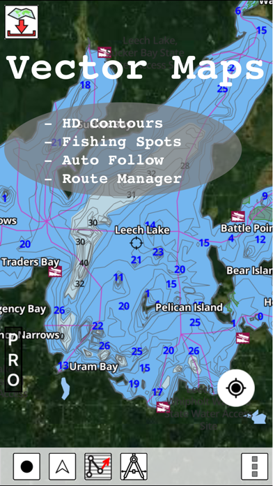
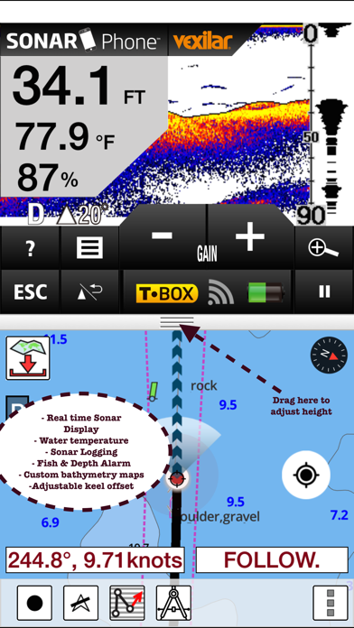
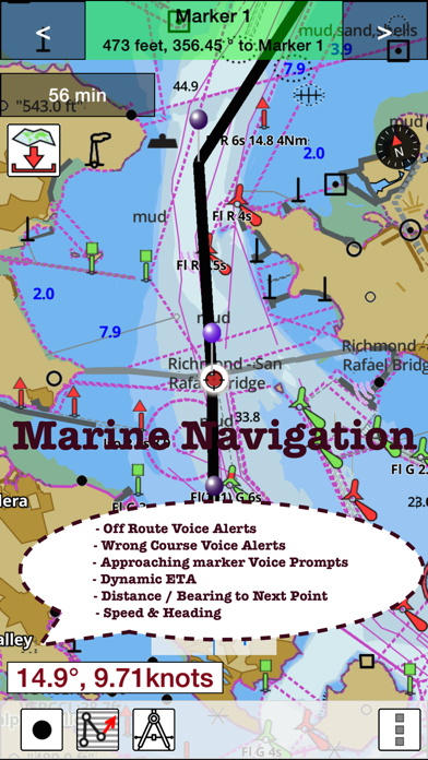
This App offers access to NOAA marine vector charts, freshwater lake maps, USACE inland river maps (HD/1ft/3ft bathymetry included where available). First marine GPS app to have route assistance with Voice Prompts for marine navigation. You can create new boating routes or import existing GPX/KML routes. It supports Nautical Charts course up orientation. Includes Tide & Currents prediction.
►FEATURES
√ Beautiful and detailed Hardware/GPU accelerated vector charts (text stays upright on rotation)
√ Long press to query the details of Marine object (Buoy, Lights, Obstruction etc).
√ Customizable depth(Ft/Fathom/Meter) and distance units (km/mi/NM)
√ Customizable Shallow Depth.
√ Record tracks, Autofollow with real-time track overlay & predicted path vector.
√ Voice Prompts for marine navigation (requires GPS )
√ 1ft / 3ft depth contour maps for anglers for selected lake maps.
√ Supports GPX/KML for boating route editing/import.
√ Tide & Currents prediction.
√ Seamless chart quilting of marine charts
√ Enter or import Waypoints.
► MAPS
The maps include coverage of all NOAA marine vector charts (ENC), USACE inland river maps, and freshwater lake maps for more than 7K lakes. The charts include HD/1ft/3ft bathymetry where available. The app also includes NOAA raster charts for some areas where NOAA ENC coverage is not available. It includes unlimited updates for 1 year.
►ROUTE MANAGEMENT / TRIP PLANNING
√ Create New Route/Edit Existing Routes
√ Move Points
√ Add points to an existing route leg
√ Delete / Rename points
√ Import GPX, KML & KMZ files
√ Plot/Edit Routes
√ Enter Waypoints
√ Share/Export Routes, Tracks & Markers
√ Reverse Routes
►GPS FEATURES
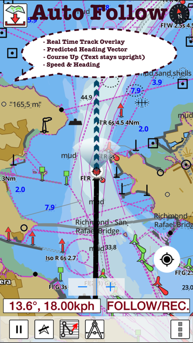
√ Auto Follow
* Real Time Track Overlay
* Predicted Path Vector
* Course Up (Text stays upright)
* Speed & Heading
√ Route Assistance With Voice Prompts
* Prompts when approaching a boating route marker
* Continous distance and ETA updates
* Alerts when sailing/boating off route
* Alerts when boating in wrong direction
√ Record Tracks
►TIDE & CURRENTS
* For US, Canada, UK, Germany & New Zealand
* High/Low Tides
* Tidal Current Prediction
* Active Current Stations
► SHARING
* Share tracks/routes/markers on Facebook & Twitter
* Export tracks/routes/markers as compressed GPX files.
Sample Nautical Charts (please visit http://gpsnauticalcharts.com/main/folio-catalog-nautical-charts-app for complete list)
SUGARLOAF KEY-KEY WEST
PORT RICHEY TAMPA BAY - CLEARWATER HBR
EAST BAY-WEST BAY FLORIDA
ST JOSEPH, ST ANDREW BAYS
INTRACOASTAL WATERWAY MATECUMBE-GRASSY KEY
CHESAPEAKE BAY CAPE CHARLES-NORFOLK HARBOR
ANCLOTE KEYS-CRYSTAL RIVER
ST JOSEPH SOUND
MIAMI HARBOR
Minnesota lakes - Kabetogama, Minnetonka, Waconia,Leech,Mille Lacs
Lake Keowee,Jocassee,Hartwell,Greenwood,Lake Murray
Mark Twain,Ozarks,Table Rock
Lake St. Clair
Lake Kentucky
KEY WEST-THE MISSISSIPPI RIVER
SAN PEDRO CHANNEL
LAKE MICHIGAN STONY LAKE-POINT BETSIE
APALACHICOLA BAY-CAPE SAN BLAS
EAST CAPE-MORMON KEY
CAPE HENLOPEN-INDIAN RIVER INLET
CHESAPEAKE BAY CAPE HENRY-THIMBLE SHOAL LIGHT
DULUTH-SUPERIOR HARBOR
MONHEGAN ISLAND-CAPE ELIZABETH
LAKE ONTARIO - CLAYTON-FALSE DUCKS ISL
Lake Winnipesaukee
SAN FRANCISCO ENTRANCE
MIAMI-MARATHON, FLORIDA BAY
CAPE MAY-FENWICK ISLAND
MISSISSIPPI RIVER-GALVESTON
CAPE CANAVERAL-KEY WEST
DELAWARE RIVER WILMINGTON-PHILADELPHIA
FLORIDA KEYS SOMBRERO KEY-SAND KEY
SAN PABLO BAY
RAINY LAKE BIG ISLAND MINN-OAKPOINT ISL ONT
INTRACOASTAL WATERWAY - BISCAYNE BAY
EVERGLADES NTL PARK - SHARK RVR-LOSTMANS RVR
MIAMI-MARATHON & FLORIDA BAY
BLACKBURN BAY
LAKE HURON
LAKE TAHOE
STRAITS OF MACKINAC
NORFOLK HARBOR & ELIZABETH RIVER
SAN DIEGO-SANTA ROSA ISLAND
DELAWARE BAY
CHOPTANK RIVER CAMBRIDGE-GREENSBORO
FORT LAUDERDALE PORT EVERGLADES
ST SIMONS SOUND-TOLOMATO RIVER
CHESAPEAKE DELAWARE CANAL
PLEASE NOTE: Continued use of GPS running in the background can dramatically decrease battery life.
►FEATURES
√ Beautiful and detailed Hardware/GPU accelerated vector charts (text stays upright on rotation)
√ Long press to query the details of Marine object (Buoy, Lights, Obstruction etc).
√ Customizable depth(Ft/Fathom/Meter) and distance units (km/mi/NM)
√ Customizable Shallow Depth.
√ Record tracks, Autofollow with real-time track overlay & predicted path vector.
√ Voice Prompts for marine navigation (requires GPS )
√ 1ft / 3ft depth contour maps for anglers for selected lake maps.
√ Supports GPX/KML for boating route editing/import.
√ Tide & Currents prediction.
√ Seamless chart quilting of marine charts
√ Enter or import Waypoints.
► MAPS
The maps include coverage of all NOAA marine vector charts (ENC), USACE inland river maps, and freshwater lake maps for more than 7K lakes. The charts include HD/1ft/3ft bathymetry where available. The app also includes NOAA raster charts for some areas where NOAA ENC coverage is not available. It includes unlimited updates for 1 year.
►ROUTE MANAGEMENT / TRIP PLANNING
√ Create New Route/Edit Existing Routes
√ Move Points
√ Add points to an existing route leg
√ Delete / Rename points
√ Import GPX, KML & KMZ files
√ Plot/Edit Routes
√ Enter Waypoints
√ Share/Export Routes, Tracks & Markers
√ Reverse Routes
►GPS FEATURES
√ Auto Follow
* Real Time Track Overlay
* Predicted Path Vector
* Course Up (Text stays upright)
* Speed & Heading
√ Route Assistance With Voice Prompts
* Prompts when approaching a boating route marker
* Continous distance and ETA updates
* Alerts when sailing/boating off route
* Alerts when boating in wrong direction
√ Record Tracks
►TIDE & CURRENTS
* For US, Canada, UK, Germany & New Zealand
* High/Low Tides
* Tidal Current Prediction
* Active Current Stations
► SHARING
* Share tracks/routes/markers on Facebook & Twitter
* Export tracks/routes/markers as compressed GPX files.
Sample Nautical Charts (please visit http://gpsnauticalcharts.com/main/folio-catalog-nautical-charts-app for complete list)
SUGARLOAF KEY-KEY WEST
PORT RICHEY TAMPA BAY - CLEARWATER HBR
EAST BAY-WEST BAY FLORIDA
ST JOSEPH, ST ANDREW BAYS
INTRACOASTAL WATERWAY MATECUMBE-GRASSY KEY
CHESAPEAKE BAY CAPE CHARLES-NORFOLK HARBOR
ANCLOTE KEYS-CRYSTAL RIVER
ST JOSEPH SOUND
MIAMI HARBOR
Minnesota lakes - Kabetogama, Minnetonka, Waconia,Leech,Mille Lacs
Lake Keowee,Jocassee,Hartwell,Greenwood,Lake Murray
Mark Twain,Ozarks,Table Rock
Lake St. Clair
Lake Kentucky
KEY WEST-THE MISSISSIPPI RIVER
SAN PEDRO CHANNEL
LAKE MICHIGAN STONY LAKE-POINT BETSIE
APALACHICOLA BAY-CAPE SAN BLAS
EAST CAPE-MORMON KEY
CAPE HENLOPEN-INDIAN RIVER INLET
CHESAPEAKE BAY CAPE HENRY-THIMBLE SHOAL LIGHT
DULUTH-SUPERIOR HARBOR
MONHEGAN ISLAND-CAPE ELIZABETH
LAKE ONTARIO - CLAYTON-FALSE DUCKS ISL
Lake Winnipesaukee
SAN FRANCISCO ENTRANCE
MIAMI-MARATHON, FLORIDA BAY
CAPE MAY-FENWICK ISLAND
MISSISSIPPI RIVER-GALVESTON
CAPE CANAVERAL-KEY WEST
DELAWARE RIVER WILMINGTON-PHILADELPHIA
FLORIDA KEYS SOMBRERO KEY-SAND KEY
SAN PABLO BAY
RAINY LAKE BIG ISLAND MINN-OAKPOINT ISL ONT
INTRACOASTAL WATERWAY - BISCAYNE BAY
EVERGLADES NTL PARK - SHARK RVR-LOSTMANS RVR
MIAMI-MARATHON & FLORIDA BAY
BLACKBURN BAY
LAKE HURON
LAKE TAHOE
STRAITS OF MACKINAC
NORFOLK HARBOR & ELIZABETH RIVER
SAN DIEGO-SANTA ROSA ISLAND
DELAWARE BAY
CHOPTANK RIVER CAMBRIDGE-GREENSBORO
FORT LAUDERDALE PORT EVERGLADES
ST SIMONS SOUND-TOLOMATO RIVER
CHESAPEAKE DELAWARE CANAL
PLEASE NOTE: Continued use of GPS running in the background can dramatically decrease battery life.
Apple AppStore - Google Play
Discussions, Ratings, and Reviews for i-Boating: USA Marine Charts App
Leave feedback and review i-Boating: USA Marine Charts
Featured Apps
MediaHub
Top News
Stocktracker
Free Apps (TOP)
Free Apps (NEW)
Paid Apps (TOP)
Paid Apps (NEW)
Top Grossing Apps
Jobsearch Apps
News Apps
Business Apps
Finance Apps
HTML Open Tag Checker
Marketing URL Builder
Percentage Calculator
Inflation Calculator
Loan Interest Calculator
Kids Apps
Dating Apps
Senior Apps
Tradesman Apps
Board Game Apps
Faith Apps
Meditation Apps
AI Apps
EV Apps
Feature Your App
Casting ATL App
The Shop Channel App
Featured: Business Solutions
Top Free Apps

ChatGPT - OpenAI OpCo, LLC
1
Introducing ChatGPT for iOS: OpenAI’s latest advancements at your fingertips.
This official app is free, syncs your history across devices, and brings you the latest from OpenAI, includi...

Freecash - Get Paid Real Money - 256 REWARDS LTD
2
Welcome to the Freecash - Earn Rewards App, your ultimate companion for earning money online! Our app allows you to take a wide variety of online tests, answer fascinating surveys and rec...

Threads - Instagram, Inc.
3
Say more with Threads — Instagram’s text-based conversation app.
Threads is where communities come together to discuss everything from the topics you care about today to what’ll be trend...

Google Gemini - Google
4
Google Gemini app is your personal, proactive and powerful AI Assistant.
With Gemini on your iPhone or iPad, you can:
- Enjoy fast and unlimited prompting powered by our biggest upgrade...
Google - Google
5
Download the Google app to stay in the know about things that matter to you. Try AI Overviews, find quick answers, explore your interests, and stay up to date with Discover. The more you ...

CapCut: Photo & Video Editor - Bytedance Pte. Ltd
6
CapCut offers easy-to-use video editing functions, in-APP fonts and effects, advanced features such as keyframe animation, smooth slow-motion, chroma key, and stabilization, to help you c...
Top Paid Apps

Geometry Dash - RobTop Games AB
1
Jump and fly your way through danger in this rhythm-based action platformer!
"Frustratingly wonderful" - Kotaku
"Geometry Dash provides all of the challenge expected from an “impossibl...

Minecraft: Dream it, Build it! - Mojang
2
Dive into an open world of building, crafting and survival. Gather resources, survive the night, and build whatever you can imagine one block at a time. Explore and craft your way through...

Heads Up! - Warner Bros.
3
It's the game The New York Times called a "Sensation!" and Cosmopolitan raved “Your existence is dull and meaningless without this life-changing app!”
Get ready for endless fun with Head...

Plague Inc. - Ndemic Creations
4
Can you infect the world? Plague Inc. is a unique mix of high strategy and terrifyingly realistic simulation.
Your pathogen has just infected 'Patient Zero'. Now you must bring about th...

Balatro - Playstack Ltd
5
Welcome to the official Balatro mobile game!
Hypnotic and endlessly satisfying, Balatro is a magical mix of card games like Solitaire and Poker, that lets you twist the rules in ways nev...

Shadowrocket - Shadow Launch Technology Limited
6
Rule based proxy utility client for iPhone/iPad.
- Capture all HTTP/HTTPS/TCP traffic from any applications on your device, and redirect to the proxy server.
- Record and display HTTP, H...
Top Grossing Apps
ChatGPT - OpenAI OpCo, LLC
1
Introducing ChatGPT for iOS: OpenAI’s latest advancements at your fingertips.
This official app is free, syncs your history across devices, and brings you the latest from OpenAI, includi...
YouTube - Google
2
Get the official YouTube app on iPhones and iPads. See what the world is watching -- from the hottest music videos to what’s popular in gaming, fashion, beauty, news, learning and more. S...

MONOPOLY GO! - Scopely, Inc.
3
The wizarding world awaits! Hit GO! Roll the dice with the witches and wizards of Harry Potter! Earn MONOPOLY money, interact with your friends, family members and fellow Tycoons from aro...

TikTok - Videos, Shop & LIVE - TikTok Ltd.
4
TikTok is THE destination for mobile videos. On TikTok, short-form videos are exciting, spontaneous, and genuine. Whether you’re a sports fanatic, a pet enthusiast, or just looking for a ...

Royal Match - Dream Games
5
King Robert needs your help to restore Royal Castle’s former glory. Break the obstacles and combine amazing power-ups to beat joyful and challenging levels! Keep unlocking wonderful areas...

Paramount+ - CBS Interactive
6
Stream exclusive originals, hit movies, live sports like NFL on CBS and UEFA Champions League, all of SHOWTIME® (Premium plan only), and favorites from CBS, Nickelodeon, Comedy Central, B...
New Free Applications


BIGTOPAPPS
Contact US for Reviews.
THESHOPCHANNEL APP - Best Shopping Deals, Coupons, and Savings!
Mini Games Studio on iOS and Android.
Casting ATL, FREE on iOS and Google Play Store!
Apple TV MLS Season Pass Apple TV + Apple Music Free 3 Months
New Paid Applications


© 2026 BigTopApps -
Privacy Policy - Troubleshooting Guide - Directory - Contact Us
LiveDataLink Development.
Please note BigTopApps is not responsible for the content provided by the publicly accessible App Store API.
The BigTopApps, BigTopApps.com, and all connected websites, social media platforms, and media outlets are part of a professional website network.
Please note that we may receive compensation from various entities whose products and services we review, promote, and/or endorse.
We are independently owned and the opinions expressed here are our own, except where indicated.